Day 2 Larapinta: Birthday waterhole to Hugh Gorge

Today was a rather long day, in hindsight, it would have been better to split the walk in two. Again we have outstanding scenery.
I thank the Parks and Wildlife commission of the Northern Territory, they have created a fine walking trail and excellent camping facilities with water and clean toilets. Without the water provision it would be easy to dehydrate here. We dug a hole to see if we could locate some in the creek bed. I reckon we'd be at it for a long time !

We bought the information pack which provides all the maps and a poster. The investment was worth it.  We aren't going to walk the entire job lot, but have chosen the section between Standley Chasm and Glen Helen..

Spencer Gorge was special, with the palms and other plants unique to its location on the trail. It was much  cooler than up on the ridges. The exit walk was a good workout, challenged by the rocks strewn up the gully and lots of them.
Rocky exit.
Spencer Gorge was special, with the palms and other plants unique to its location on the trail. It was much  cooler than up on the ridges. 
Vegetation.
The trail out was simply the gully, The rise out of the gully was gradual, the walls rising in a gap of  about 50-100 metres give it an air of grandeur.
Sheer walls line the gully.
Large boulders proved a challenge to negotiate at times, finishing at an appropriately named Rocky Talus.
Rocky Talus.
Being ignorant I thought talus was some alternative name for a talon on a bird. I stand to be corrected, it's a bone on the foot. Almost there I suppose in that they are located on the foot. Maybe someone busted their talus and was in the medical profession when clambering on these rocks with a loaded backpack. Painful long recovery period no doubt.
Talus.
Exiting Spencer Gorge, we note it's a place to remember for its beauty and challenges.

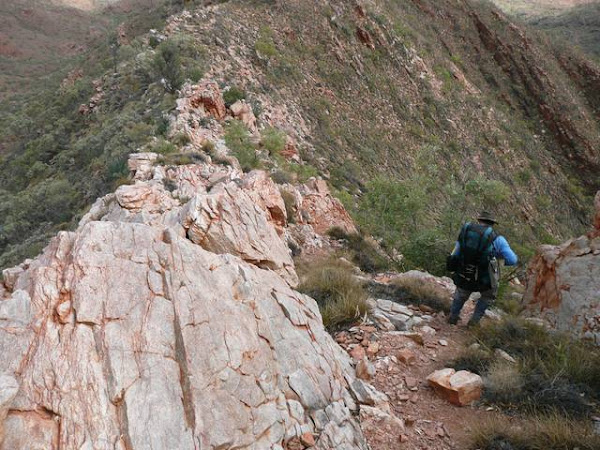
Windy Saddle lives up to its name. It was funneling through at a great rate of knots. We could have done with a few more trail markers through this saddle as the track was non-existent in places. A bit of intuition took us right up the shale like rock slope. Proper reading of the guide book would of told us that anyway ! On the whole though, most of this track is well marked, and really once up on the ridge line it's a no brainer.

View of ridge.
Razorback ridge is an apt name. Navigation and walking along it was a joy. The views just made you want to stick around, but one can't dwell for too long as there is no staying due to lack of water and shortage of daylight hours.

We get to a place called Fringe Lily creek. It's been a hard couple of days, no break in period. Tiredness is getting to us. It was tempting to stop here, only there is no water and our itinerary did not allow for change.

The great thing about this track, is that there are emergency exits if need be - head due south if need be (but the exit may be long depending on where you are !), and rangers are patrolling. The Larapinta trail runs roughly east-west along the West Macdonnell Ranges. Running parallel to it is a road (not visible from the trail) leading to Glen Helen resort and beyond, if need be, an escape can be had by setting a path to intersect it. There are also access trails at different points.

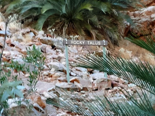
Leaving Fringe Lily creek , the track got quite rocky, indeed with names like rocky saddle and rocky talus there is no surprise. The spinifex here was especially sharp, my canvas gaiters only just providing adequate protection against the barbs.

I am fascinated by interesting plants, bugs and animals. There were some trees with interesting black bulbous clumps on them. I am frustrated in my lack of biological knowledge - never could get my head around those convoluted Latin names that my tongue cannot pronounce, but it still doesn't stop me enjoying the novelties and aesthetics of nature.

Gum tree.
Going down the gully we intercepted a couple of American blokes walking the other way. Crazily they only had an aluminium water bottle between them. Here we are consuming over 5 litres each !

Arriving at Hugh Gorge is via a creek bed. It was initially sand then moved on to boulders - lots of them.  Boulders , boulders and more boulders.

Rocks in Hugh gorge.
We come across some water holes. A welcome oasis in the desert. I can imagine that should it actually rain, there is no way you would be walking along here.
Water.
Eventually the camp site is reached. Another night looms, camp  is set up quickly and sleep is rapidly upon us.
Tent.

Blog References

Comments